
The cold tightened its grip on Jammu and Kashmir as the mercury plummeted by eight degrees in Leh in Ladakh region to register the season's lowest temperature and most parts of the Valley froze in sub-zero temperatures.

Mumbai and its adjoining areas were lashed by heavy showers on Tuesday, causing water-logging at a number of places, including railway tracks, which slowed the movement of trains and vehicles on roads.

With different agencies showing divergent predictions regarding the southwest monsoon, the central government and states are gearing up to face adversity with various line ministries reportedly being directed to undertake mock drills and hold preparatory meetings. Around 56 per cent of the net cultivable area of the country is rain-fed, accounting for 44 per cent of foodgrain production. The June-September rains contribute around 73 per cent of the annual precipitation.

There is a definite attempt to put the landslides on the backburner because news of them and climate change worry Wayanad's tourism and real estate businesses greatly. Whatever I experienced of Wayanad's 2024 by-elections; the July landslides were not a burning issue, observes Shyam G Menon.

Floodwaters of the overflowing Yamuna reached the entrance of the Supreme Court in Central Delhi on Friday as the regulator of the Delhi irrigation and flood control department at Indraprastha suffered damage on Thursday evening.
A moderate intensity earthquake measuring 5.2 on the Richter Scale hit Andaman Islands on Tuesday, the Meteorological Department said. The epicentre of the quake that struck at approximately 7.09 am at the depth of 10 kilometres was centred at 11.7 degree North latitude and 95.0 degree East longitude in the Andaman Islands region. There were no immediate reports of damage and no tsunami alert had been issued.

The current spell of weak monsoon over the country is likely to continue for the next five days, the India Meteorological Department (IMD) said on Wednesday.
Poor rainfall in rain-dependent central and southern India in the next three weeks could affect agricultural GDP growth in the coming season, a report by broking firm Motilal Oswal has said.

The flow rate at the Hathnikund barrage saw a marginal rise on Tuesday afternoon, oscillating between 50,000 and 60,000 cusecs.

A red alert has been sounded in three districts of Idukki, Thrissur and Palakkad in Kerala.

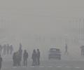
The national capital battled weather conditions in the "red category" as the maximum temperature recorded at the Palam observatory was 46.1C,

A punishing cold wave swept Delhi on Monday morning with the minimum temperature at the Safdarjung observatory, the city's base station, plunging to 1.4 degrees Celsius, the lowest in the month since January 1, 2021.

The minimum temperature in the national capital on Saturday settled at 10.2 degrees Celsius, three notches above the season's average, it said.
The tremor, measuring 3.9 on the Richter scale, was recorded at 1659 IST.

There are conflicting reports about the magnitude of the earthquake that shook Delhi and its adjoining areas. While the Indian Meteorological Department measured the quake at a scale of 4.9, the United States Geological Survey put the magnitude at 5.2 on the Richter scale.

The weather department has said that the skies are expected to be partly cloudy for the next few days in Delhi.

The meteorological department said that a deep depression in the Bay of Bengal was developing into a marginal cyclone and was set to hit the northern coast of Sri Lanka.

Rainfall in August is predicted to be below normal (less than 94 per cent of LPA), but the situation is expected to improve comparatively in September, the IMD said.

El Nino is often associated with below average warmer, dry weather across Asia Pacific region.

The orange alert implies that authorities should be ready to handle situations arising out of severe weather.

The state government has begun preparations to deal with the fallout of the cyclone as it will bring very strong wind and heavy rainfall in the region, officials said.
The minimum temperatures are very likely to fall by 2-5 degrees Celsius over most parts of East India, Central India over the next two-three days, while the spell of intense cold can extend beyond that in the Northwest part of the country.

Severe cyclonic storm Mandous will cross the coast between north Tamil Nadu and south Andhra Pradesh around December 9 night and early next day, the regional weather office said on Friday.

The very severe cyclonic storm Tauktae is likely to intensify during the next 24 hours and reach the Gujarat coast on Monday evening, the India Meteorological Department (IMD) said.

The country saw 645 events of heavy rainfall and 168 events of very heavy rainfall in November, the highest in the month in five years, the India meteorological department said on Wednesday.
The Indian Meteorological Department stated on Friday that 75 such tremors have been recorded since the December 26 earthquake.

The country can expect normal rainfall during the southwest monsoon season as a positive Indian Ocean Dipole (IOD) and a lower snow cover over the northern hemisphere are likely to counter the evolving El Nino conditions, the India meteorological department (IMD) said on Tuesday.

While there was a brief respite from the incessant downpour on Tuesday, collaborative efforts from the defence, national, and state disaster response forces took the lead in executing rescue and relief operations.

A new low pressure over south east Bay of Bengal was expected to bring more rains to Tamil Nadu, where the death toll rose to 184.

East and northeast India recorded 29 per cent rain deficit -- 141.5 mm against the normal of 199.9 mm -- from March 1 to May 3.

The India Meteorological Department has issued an 'orange' alert.

The weather department attributed the unusual heat to the lack of rainfall due to the absence of active western disturbances over north India and any major system over south India.
Many parts of the country have received good rainfall and others, including the capital where the monsoon has not moved in so far, woke up to pre-monsoon showers on Wednesday.
Cyclonic storm Ward, which had weakened and formed into a depression, is likely to cross the Tamil Nadu coast between Kaniyakumari and Nagapattinam districts on Tuesday night, meteorological department officials said on Tuesday. "The depression, which currently lies over Sri Lanka, is likely to move in the west direction and cross Tamil Nadu coast," they said. Under its influence, heavy rainfall is likely to occur in Tamil Nadu and Puducherry region in the next 24 hours.

State capital Lucknow shuddered at 0.7 degrees Celsius, while Bahraich recorded a low of 0.2 degrees Celsius.
The epicentre of the earthquake lay in India-Pakistan border region of Jammu and Kashmir.
The monsoon situation in the northern region of the country will improve over the next couple of days and August will receive above average rainfall, Union Minister for Agriculture Sharad Pawar has assured.Quoting the latest report from the Indian Meteorological Department, Pawar told reporters in Hyderabad on Saturday that the states of Punjab, Haryana, western Uttar Pradesh and parts of Bihar and Himachal Pradesh will receive 86 per cent rainfall during July.
The Indian Meteorological Department said though Cyclone Laila has weakened, the danger is not over yet as there were signs of it re-emerging in northern Bay of Bengal over the weekend.

Cyclonic storm Laila finally struck the Andhra coast 50 km north of Bapatla town of Guntur district on Thursday afternoon.